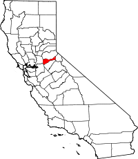
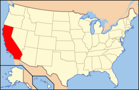
Amador County, California
| County of Amador | |||
|---|---|---|---|
| — County — | |||
 |
|||
|
|||
| Nickname(s): The Heart of the Mother Lode | |||
 |
|||
 |
|||
| Country | United States | ||
| State | California | ||
| Region | Sierra Nevada | ||
| Incorporated | 1854 | ||
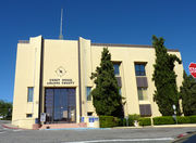
| County seat | Jackson | ||
| Largest city | Ione | ||
| Area | |||
| - Total | 605 sq mi (1,566.9 km2) | ||
| - Land | 593 sq mi (1,535.9 km2) | ||
| - Water | 12 sq mi (31.1 km2) | ||
| Population (2000) | 38,471 | ||
| - Density | 23/sq mi (8.9/km2) | ||
| Time zone | Pacific Standard Time (UTC-8) | ||
| - Summer (DST) | Pacific Daylight Time (UTC-7) | ||
| Area code(s) | 209 | ||
| Website | www.co.amador.ca.us | ||
Amador County is a county located in the Sierra Nevada of the U.S. state of California. As of 2005, the population was 38,471. The county seat is Jackson.
Amador County bills itself as "The Heart of the Mother Lode" and lies within the Gold Country. There is a substantial wine-growing industry in the county.
Contents |
History
Amador County was created in 1854 from parts of Calaveras and El Dorado Counties. In 1864, part of the county's territory was given to Alpine County.
The county is named for Jose Maria Amador, soldier, rancher and miner, who was born in San Francisco in 1794, the son of Sergeant Pedro Amador (a Spanish soldier who settled in California in 1771) and younger brother to Sinforosa Amador.
In 1848, Jose Maria Amador, with several Native Americans, established a successful gold mining camp near the present town of Amador City. In Spanish, the word amador means "one who loves."
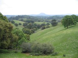
Geography
Amador County is located approximately 45 miles (72 km) southeast of Sacramento in a part of California known as the foothills of the Sierra Nevada Mountains.
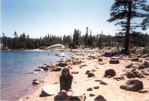
According to the U.S. Census Bureau, the county has a total area of 605 square miles (1,570 km2), of which 593 square miles (1,540 km2) is land and 12 square miles (31 km2) (1.94%) is water. Water bodies in the county include Lake Amador, Lake Camanche, Pardee Reservoir, Bear River Reservoir, Silver Lake, Sutter Creek, Cosumnes River, Mokelumne River, and Jackson Creek.
Amador County ranges in elevation from approximately 250 feet (76 m) in the western portion of the county to over 9,000 feet (2,700 m) in the eastern portion of the county. The county is bordered on the north by the Cosumnes River and on the south by the Mokelumne River.
Cities and towns
- Amador City
- Ione
- Jackson
- Plymouth
- Sutter Creek
Unincorporated places
- Drytown
- Fiddletown
- Martell
- Pine Grove
- Pioneer
- River Pines
- Volcano
Adjacent counties
- Calaveras County, California - south
- San Joaquin County, California - southwest
- Sacramento County, California - west
- El Dorado County, California - north
- Alpine County, California - east
National protected area
- Eldorado National Forest (part)
- Mokelumne Wilderness (part)
Shenandoah Valley
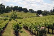
Though not as well known as the Napa Valley AVA or Sonoma Valley AVA wine growing regions of California, the Shenandoah Valley was once the princicpal wine growing region of California. With the discovery of gold, the area quickly became a mecca for those trying to make their fortune. In the process numerous wineries sprouted up many of whose vineyards are still in use by wineries today. The decline of the California Gold Rush coupled with the onset of Prohibition devastated the wine making region of Amador County. Today this area has been resurrected and is now home to over 40 different wineries. Amador County is renowned for its Zinfandel, but many other varietals are produced as well. Amador County has a high percentage of old Zinfandel vines. Some of the Zinfandel vineyards in this county are more than 125 years old; including the original Grandpère vineyard, planted with Zinfandel before 1869, making the vineyard the believed to be oldest Zinfandel vineyard in America.[2]. This 10-acre vineyard is home to the oldest Zinfandel vines on Earth, with proof of existence dating to 1869 when the vineyard was listed as a descriptor on a deed from the U.S. Geological Survey. Also grant deed in Amador County records proves its existence in 1869. These old vines produce intense flavors allowing winemakers to make the outstanding Zinfandels for which this area is famous.
Gold mining
There are numerous gold mines in Amador County including the Argonaut Mine, the Kennedy Mine, and the Sutter Mine.
Attractions
Amador County is home of the Gold Rush era in California. Many century-old gold-mining places in the county are now popular tourist destinations. Amador County offers several tourists destinations and things to do:
- Jackson Main Street - antique shops
- Sutter Creek Main Street - antique shops, [2] Sutter Creek Theater
- Jackson Rancheria - casino and hotel
- Volcano Theater Company and the Cobblestone Theater and the St. George Hotel in Volcano
- Mace Meadows Golf Course in Pioneer
- Old Mill Shopping Center in Martell
- Underground caves with tours
- Campgrounds areas with gold-panning activities
- Wineries with wine-tasting activities
- Mokelumne River - fishing, gold panning, whitewater kayaking, swimming, picnics, water play
- Lakes for boating and fishing
- Winter Ski Resorts - for skiers, snowboarders, etc.
- Outdoor Activities - camping, fishing, picnicing, ATV riding, backpacking, hiking, lake kayaking, horseback riding, whitewater kayaking, birding, snowshoeing, cross-country skiing, rock climbing, etc.
- Historic sites: Kennedy Mine in Jackson, Chew Kee Store in Fiddletown, Knight Foundry in Sutter Creek
Roaring Camp Mining Company
Transportation infrastructure
Major highways
 State Route 16
 State Route 26
 State Route 49
 State Route 88
 State Route 104
 State Route 124
Public transportation
Amador Regional Transit System (ARTS) provides service in Jackson and the nearby communities. Connections are available to Sacramento and to Calaveras County.
Airports
Amador County Airport is a general aviation airport located near Jackson.
Demographics
As of the census[3] of 2000, there were 35,100 people, 12,759 households, and 9,071 families residing in the county. The population density was 59 people per square mile (23/km²). There were 15,035 housing units at an average density of 25 per square mile (10/km²). The racial makeup of the county was 85.79% White, 3.87% Black or African American, 1.78% Native American, 1.00% Asian, 0.10% Pacific Islander, 5.04% from other races, and 2.41% from two or more races. 8.91% of the population were Hispanic or Latino of any race. 14.9% were of German, 12.6% English, 11.7% Irish, 8.8% Italian and 7.3% American ancestry according to Census 2000. 93.1% spoke English and 5.1% Spanish as their first language.
There were 12,759 households out of which 26.2% had children under the age of 18 living with them, 58.9% were married couples living together, 8.7% had a female householder with no husband present, and 28.9% were non-families. 23.9% of all households were made up of individuals and 11.3% had someone living alone who was 65 years of age or older. The average household size was 2.39 and the average family size was 2.81.
In the county the population was spread out with 20.6% under the age of 18, 6.9% from 18 to 24, 26.2% from 25 to 44, 28.3% from 45 to 64, and 18.0% who were 65 years of age or older. The median age was 43 years. For every 100 females there were 122.5 males. For every 100 females age 18 and over, there were 123.4 males.
The median income for a household in the county was $42,280, and the median income for a family was $51,226. Males had a median income of $39,697 versus $28,850 for females. The per capita income for the county was $22,412. About 6.10% of families and 9.20% of the population were below the poverty line, including 13.10% of those under age 18 and 5.40% of those age 65 or over.
Politics
| Year | GOP | DEM | Others |
|---|---|---|---|
| 2008 | 56.3% 10,561 | 41.7% 7,813 | 2.0% 395 |
| 2004 | 62.1% 11,107 | 36.6% 6,541 | 1.3% 243 |
| 2000 | 56.7% 8,766 | 38.2% 5,906 | 5.1% 792 |
| 1996 | 47.5% 6,870 | 40.6% 5,868 | 11.9% 1,714 |
| 1992 | 35.5% 5,477 | 34.3% 5,286 | 30.3% 4,671 |
| 1988 | 55.9% 6,893 | 42.1% 5,197 | 2.0% 148 |
| 1984 | 61.5% 6,986 | 36.9% 4,188 | 1.7% 189 |
| 1980 | 55.9% 5,401 | 33.0% 3,191 | 11.1% 1,078 |
| 1976 | 46.1% 3,699 | 50.4% 4,037 | 3.5% 282 |
| 1972 | 53.4% 3,533 | 40.9% 2,705 | 5.7% 378 |
| 1968 | 42.1% 2,269 | 45.3% 2,440 | 12.6% 681 |
| 1964 | 33.0% 1,682 | 66.9% 3,410 | 0.1% 6 |
| 1960 | 44.5% 2,175 | 55.0% 2,690 | 0.5% 22 |
Amador is a strongly Republican county in Presidential and congressional elections. The last Democrat to win a majority in the county was Jimmy Carter in 1976.
Amador is part of California's 3rd congressional district, which is held by Republican Dan Lungren. In the State Assembly, Amador is part of the 10th district, which is held by Democrat Alyson Huber. In the State Senate, Amador is part of the 1st district, which is held by Republican Dave Cox.
On Nov. 4, 2008 Amador County voted 64.0 % for Proposition 8 which amended the California Constitution to ban same-sex marriages.
See also
- List of school districts in Amador County, California
- Amador High School
References
- ↑ [1], Judicial Council of California, Accessed August 2, 2009.
- ↑ http://articles.sfgate.com/2005-07-28/wine/17381773_1_old-vine-new-vine-zinfandel
- ↑ "American FactFinder". United States Census Bureau. http://factfinder.census.gov. Retrieved 2008-01-31.
External links
- MyAmador: Search Amador County businesses, services, organizations and communities
- Amador County website
 |
El Dorado County | |
||
| Sacramento County | Alpine County | |||
| San Joaquin County | Calaveras County |
|
|||||||||||||||||
|
|||||||||||||||||||||||